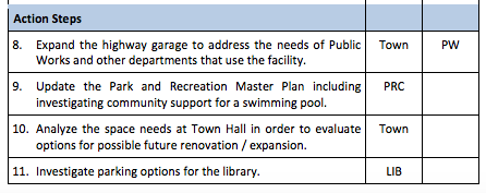
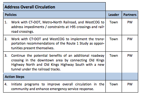
Buy land as it becomes available near public schools; consider building a public indoor swimming pool; consider digging a tunnel under the railroad tracks to connect Old Kings Highway South with Old Kings Highway North; “investigate parking options for the library.”

Cover of the draft Darien Town Plan of Conservation and Development for the decade starting in 2016
These are some of the ideas for what the town government could do in the next 10 years in the draft of a plan to guide local decision-makers for the next decade. The document, called the Town Plan of Conservation and Development, is mandated by state government.
The plan doesn’t mandate what the town necessarily will do over the next 10 years, but it does influence town decision-makers. The town Planning and Zoning Commission wants to know what you think of the draft plan before they adopt it as a guideline. You can email your reactions and ideas to pocd@darienct.gov.
“A plan of conservation and development is an advisory document — it’s not something that dictates what the community has to do,” said Glenn Chalders with Planmetrics, the consulting firm hired by the town to help devise the plan. “It’s an opportunity for us to take a look at things that are affecting the community […] and to actually devise what we think are good strategies for the community going forward.”
Parts of the plan describe the town and how it’s population has changed, important things to conserve in Darien and how to guide commercial and residential development in town. Although it’s about 170 pages long, the plan rarely delves into details, especially on specific proposals for action. Sometimes it describes proposed goals and policies in several paragraphs.
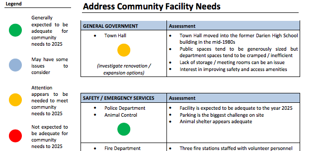
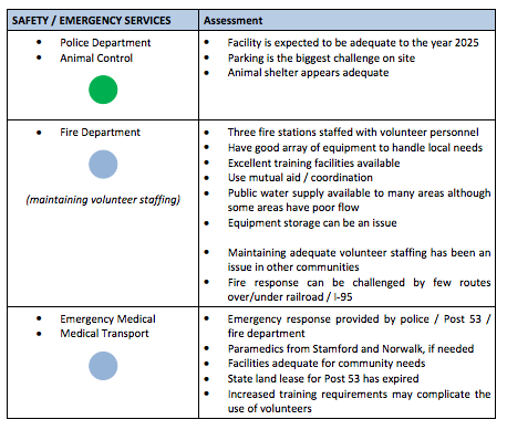
This article concentrates on recommendations for developing community facilities in town over the next 10 years.
The draft, available on the town website, was presented last week to the public and to the Representative Town Meeting. It includes a description of the town’s assets — including its schools, parks and public facilities — and a description of what’s considered important to preserve or change in Darien.
___________
“The real reason for doing the plan is getting everybody on the same page […] The plan gives us the opportunity to ask the question, ‘What type of community do we want to be?’ and try to find consensus, try to get everybody on the same page and identify the things we as a community should be looking at and working on over the nexty 10 years or so. So, again, it’s meant to be a long-term visionary type document.”
— Glenn Chalders of Planmetrics
___________
Town officials, community groups and the public have been contributing their concerns and opinions in the commission’s effort to see what consensus may exist in town.
Some recommendations are strong ones (saying the town should do something or intends to do something) but most are recommendations to consider an idea or look into an identified problem.
Consultants for the town Planning and Zoning Commission are putting together final recommendations on what the P&Z Commission should consider before adopting the plan by late spring. If the P&Z doesn’t adopt the plan by June, Darien could be temporarily ineligible for certain state aid programs.
The Planning & Zoning Commission, as well as the town P&Z Department and consultants with Planmetrics are working on the draft, expected to be presented to the commission on March 8.
Where You Can Read the Draft Yourself
The thick document is available for anyone to look through at Darien Library and at the Planning & Zoning Department in Town Hall.
____________
You can email your reactions and ideas to pocd@darienct.gov. But act soon: The town’s consultants had hoped to get recommendations from the public in by last Friday and are now working on incorporating them into the draft plan to be presented to the P&Z Commission early in March.
____________
It’s even easier to read online. You can find it on this Web page on the town website, where it’s posted in five parts (all in PDF format), and you can go directly to those parts from here (chapter titles are given after the dash marks on each line):
1. Cover and Introduction — Introduction; Planning Issues; Conditions & Trends
2. Conservation Strategies — Maintain and Enhance Community Character; Preserve Open Space; Manage Coastal Resources; Protect Natural Resources
3. Development Strategies — Maintain and Enhance Downtown; Transform Noroton Heights Business Area; Manage Residential Development; Guide Business and Economic Development
4. Infrastructure Strategies — Maintain and Enhance Community Facilities; Address Transportation Needs; Manage Utility Infrastructure; Promote Sustainability and Resiliency
5. Implementation — Future Land Use Plan; Implementation; Conclusion
The second draft as one large PDF file is here (about 170 pages long).
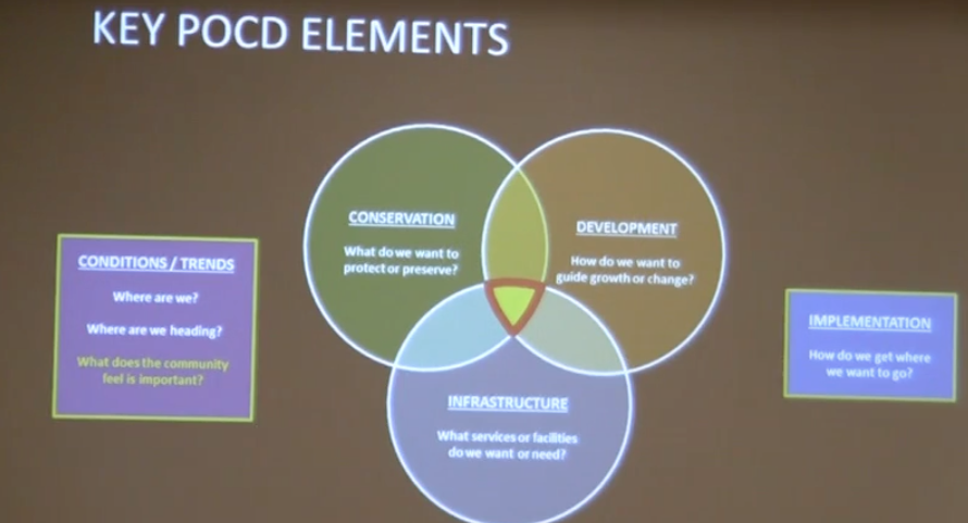
Parts of the draft plan described in a slide during a presentation by Glenn Chalders of Planmetrics at the Darien Library on Feb. 22.
Some Excerpts from the Draft Plan
Here’s a very small sampling of some of the observations and ideas in the plan, from the “Development Strategies” section, Chapter 12, about town facilities: