
Update 7:32 a.m., Monday:
The Tropical Storm Warning has been cancelled by the National Weather Service for southern Fairfield County and only remains for areas farther east as Hermine shifts in that direction.
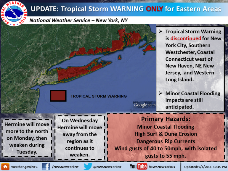
The Tropical Storm Watch was discontinued late Sunday night. (National Weather Service graphic)
A “Coastal Flooding Statement” has been issued for coastal Fairfield County (updated at 5:10 a.m.) warning of “minor, localized, moderate flooding” along the coast, with tidal departures of 1 to 2 feet, “coming around the times of high tide” this afternoon and night.
Here’s the weather service’s Darien-specific forecast for the next few days (as of 6:56 a.m.):
Update, 6:50 p.m., Sunday:
Gusty winds may blow things left outdoors late Sunday and Monday, swimmers may encounter rip currents, and high tides are expected to be above average, Darien police warned in an announcement Sunday afternoon.
Here’s the announcement, emailed at 4:20 p.m. and on the department’s website (followed by a graphic showing rip current safety tips issued by the National Weather Service:
With the approach of Tropical Storm Hermine the potential exists for dangerous rip currents and above average high tides along the Darien coastline over the next few days. Swimmers are urged to exercise caution if they are in or near the water and to adhere to any warnings posted at the local beaches.
In addition to the rip currents, the forecast also warns of the potential for minor flooding of coastal areas during the high tide cycle occurring around 2:00 early Monday morning.
The town is forecasted to experience sustained winds of 20-25 mph with the potential for gust of 35-40 mph starting Sunday afternoon and continuing into Monday. Residents are encouraged to secure items that may be prone to blowing around and or wind damage.

From the National Weather Service
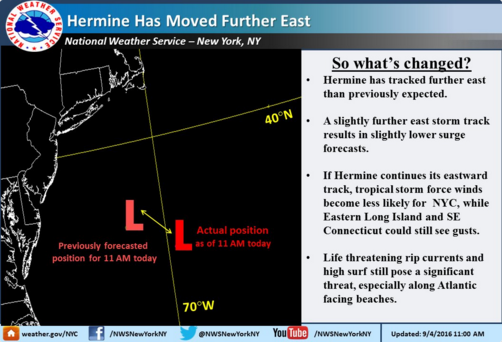
National Weather Service update issued at 11 a.m., Sunday, Sept. 4
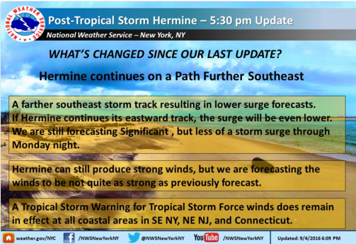
National Weather Service update issued at 6:09 p.m., Sunday, Sept. 4
Original article: 10:24 a.m., Sunday:
Power outages Sunday and Monday are possible with high wind gusts of as much as 45 mph, and 2 to 4 feet of coastal flooding is possible, weather forecasters are saying.
As for rain itself? Not so much.
High tide on Sunday is at 1:48 p.m. For Monday, 2:10 a.m. and 2:28 p.m., according to the Darien Boat Club website.
According to the Weather Channel’s website, the hourly Darien forecast for Sunday, as of 10:17 a.m., shows no rain and winds only as high as 16 mph through midnight.
Meteorologist Ryan Hanrahan of NBC Connecticut says that the storm is headed farther out to sea than originally forecasted: “It looks like the impacts from Hermine won’t be nearly as severe as it seemed it would be a couple days ago,” he said in a broadcast segment posted on his Facebook timeline.
“We are a little bit more optimistic today for our local area — it doesn’t look quite as strong this far out from the center,” said WTNH, Channel 8 Meteorologist Gil Simmons in a Sunday morning broadcast segment posted on Facebook. He added: “But we’re still going to have some wind to deal with tonight and tomorrow, and we’re also going to watch those high tides.”
He said he thinks “the roughest weather” is tonight and Monday.
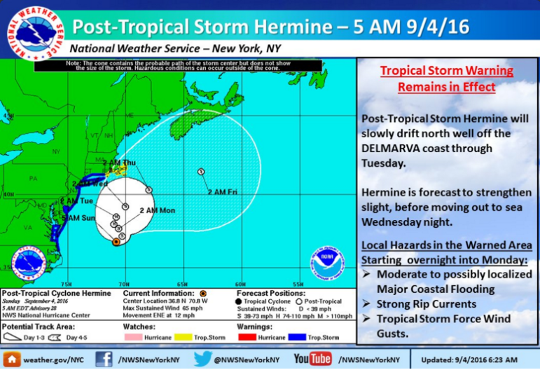
Graphic from the National Weather Service
First Selectman Jayme Stevenson suggests town residents “particularly along our coast, should begin prep for Tropical Storm Hermine.”
The National Weather Service has issued a Tropical Storm Warning for southern Fairfield County that says we can expect winds of 15 to 25 mph with gusts of up to 45 mph, according to the 8:23 a.m. update. If you have anything outside that may be damaged or may fly away in the wind, get it indoors or fasten it down.
The weather service says the impact of high winds is limited:
POTENTIAL IMPACTS: LIMITED
-
DAMAGE TO PORCHES, AWNINGS, CARPORTS, SHEDS, AND UNANCHORED MOBILE HOMES. UNSECURED LIGHTWEIGHT OBJECTS BLOWN ABOUT.
-
MANY LARGE TREE LIMBS BROKEN OFF. A FEW TREES SNAPPED OR UPROOTED, BUT WITH GREATER NUMBERS IN PLACES WHERE TREES ARE SHALLOW ROOTED.
-
SOME FENCES AND ROADWAY SIGNS BLOWN OVER.
-
A FEW ROADS IMPASSABLE FROM DEBRIS, PARTICULARLY WITHIN URBAN OR HEAVILY WOODED PLACES.
-
HAZARDOUS DRIVING CONDITIONS ON BRIDGES AND OTHER ELEVATED ROADWAYS. – SCATTERED POWER AND COMMUNICATIONS OUTAGES.
As for coastal flooding, the weather service says:
LIFE-THREATENING STORM SURGE POSSIBLE
        - PEAK STORM SURGE INUNDATION: THE POTENTIAL FOR 2-4 FEET
          ABOVE GROUND SOMEWHERE WITHIN SURGE PRONE AREAS
        - WINDOW OF CONCERN: BEGINS EARLY THIS AFTERNOON
For those in low-lying areas prone to coastal flooding:
-
TO BE SAFE, EARNESTLY PREPARE FOR THE POTENTIAL OF SIGNIFICANT STORM SURGE FLOODING IMPACTS. EVACUATION EFFORTS SHOULD NOW BE UNDERWAY.
-
LIFE THREATENING INUNDATION IS POSSIBLE. FAILURE TO HEED EVACUATION ORDERS MAY RESULT IN SERIOUS INJURY OR LOSS OF LIFE. LEAVE IF EVACUATION ORDERS ARE GIVEN FOR YOUR AREA. CONSIDER VOLUNTARY EVACUATION IF RECOMMENDED. POOR DECISIONS MAY NEEDLESSLY RISK LIVES.
Forecasters added this about the possible impacts from coastal flooding:
POTENTIAL IMPACTS:
-
SIGNIFICANT AREAS OF INUNDATION WITH STORM SURGE FLOODING ACCENTUATED BY WAVES. DAMAGE TO SEVERAL BUILDINGS, MAINLY NEAR THE COAST.
-
SECTIONS OF NEAR-SHORE ESCAPE ROUTES AND SECONDARY ROADS BECOME WEAKENED OR WASHED OUT, ESPECIALLY IN USUALLY VULNERABLE LOW SPOTS.
-
FLOOD CONTROL SYSTEMS AND BARRIERS MAY BECOME STRESSED. MAJOR BEACH EROSION WITH HEAVY SURF BREACHING DUNES. VERY DANGEROUS SURF AND RIP CURRENTS.
-
MODERATE DAMAGE TO MARINAS, DOCKS, BOARDWALKS, AND PIERS. SEVERAL SMALL CRAFT BROKEN AWAY FROM MOORINGS, ESPECIALLY IN UNPROTECTED ANCHORAGES.
Although “locally heavy rain and nuisance flooding may still occur,” the weather service says, there’s simply no significant amount of rain in the forecast.
Darien police suggest you sign up for the town’s CodeRed phone-alert service, which will inform you about any town weather emergencies or warnings: “Town officials will send out CodeRED alerts related to any potential storm activity, evacuations, shelter locations, and other emergencies making it an essential preparedness tool to stay safe.”
You can sign up for emails or phone notifications here.
If a power outage does come and lasts, the town is able to set up temporary shelters, and there is electricity and wifi service at both of the Interstate 95 rest stops in Darien, which are both equipped with generators.
Forecast for Days Ahead
The National Weather Service’s Darien-specific forecast says tropical storm conditions are possible Sunday night through Wednesday. Here’s the Darien forecast for the next several days (as of the 8:56 a.m. update):