Merritt Parkway Logo user:Vrysxy on Wikimedia Commons https://commons.wikimedia.org/wiki/File:Merritt_Pkwy_Shield.svg

ConnDOT Plans to Have Merritt Parkway Signs Replaced in 2018

Download PDF

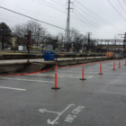
The Connecticut Department of Transportation is developing plans to replace the highway signs and their support structures on a 38.3-mile stretch of the Merritt Parkway from the Connecticut/New York border in Greenwich to the Stratford/Milford town line. ______________

— an announcement from the Connecticut Department of Transportation

______________

“This project is necessary because of the age, condition and structural integrity of these signs and their support systems– some of which have little remaining reflectivity and are literally falling apart after 20 years along the roadway,” said ConnDOT Commissioner James P. Redeker. “This creates a safety issue, not to mention an inconvenience and distraction for motorists. As part of our ongoing asset management program, we are constantly evaluating the condition of all of our highways, bridges and ancillary structures. This project is a direct result of those efforts.”

Replacement of the highway signing will consist of removing and replacing existing overhead, side-mounted, post-mounted, and variable message signs (including one in Orange on the Wilbur Cross parkway) using some of the existing sign supports, as well as many new support structures.

DOT

Merritt Pkwy Project to Close Ramps Wednesday, April 26, Greenwich to New Canaan

Download PDF

The Connecticut Department of Transportation is announcing that construction will be resuming on Route 15 (Merritt Parkway) in Stamford and New Canaan from the Greenwich town line just north of Exit 31, North Street, to the vicinity of Exit 37, Route 124 (South Avenue) beginning on Monday, April 17, 2017. 

The project consists of 6.5 miles of roadway resurfacing, safety improvements, and landscaping enhancements.  The work also includes rehabilitation of five historic bridges over Route 15. ____________

— an announcement from the Connecticut Department of Transportation

____________

Department of Transportation Project No. 0135-0270 was awarded to O&G Industries at a cost of $53,031,742.62 on July 23. 2013 and is scheduled to be completed by July, 2017. LANE CLOSURE AND DETOUR INFO

The following nighttime periodic closures of the northbound and southbound on/off ramps at Exits 34, 35, 36, and 37 on or about Wednesday, April 26 for joint sealing in the City of Stamford and Town of New Canaan will be required.

Parking Noroton Heights Station 03-28-17

Town Officials Consider Parking Situation at Noroton Heights Station as Platform Project Starts

Download PDF

With the passenger platform replacement project now started at the Noroton Heights Railroad Station, town officials have taken some steps to try to minimize the parking spaces that commuters can’t use during construction, and if that’s not enough, they’ve identified some other options. The project to replace all the concrete platforms on either side of the tracks has begun, with the western end of the south platform, roughly half of it, already marked off with yellow tape and now unusable for passengers. Work on that quarter of the platforms was expected to continue to about mid-summer, ConnDOT said during the initial planning for the project last year. A number of parking spaces up against the platform are already out of commission. At Monday’s Board of Selectmen meeting, members of the board said they were concerned about commuters losing spaces and wanted to know if the town could help with that.

DOT

State to Repave Rt 1 in Darien This Summer: You Won’t Believe What They’re Considering

Download PDF

The state Department of Transportation has informed town officials it plans to pave the Post Road through Darien this summer, Darien Police Capt. Donald Anderson told the Police Commission on Wednesday — and he passed on an unusual request. Officials from the department commonly known as “ConnDOT” told town officials that they’re aware of a traffic study about Route 1 done by the now-defunct Southwestern Regional Planning Agency (which has been replaced with the Western Council of Governments,commonly known as “WestCOG”). That traffic study suggested replacing one of the two lanes for traffic going in each direction with just one lane apiece, and using the space created to paint in turning lanes on the road and such amenities as bicycle lanes. The state wants to know if the town thinks that’s a good idea, in whole or, if in part, where the single lanes might work. “They reached out to me, asking if the Legal Traffic Authority [which is the Police Commission in Darien] would be looking to implement any or all of the SWRPA recommendations as far as the roadway markings on U.S. 1,” Anderson told the commission.