Weather
Showers, Thunderstorm Likely Late Today, Tonight — Watch for Wind Gusts
|

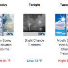
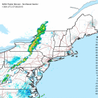
Wind gusts are what to watch out for in a thunderstorm likely to hit Darien sometime between 5 p.m. and 1 a.m., the National Weather Service says. While it’s possible that the thunderstorm could be severe, the likelihood is low, forecasters say. According to WNBC-TV weather, showers may come as early as 2 p.m. And Sam Kantrow, a forecaster for WTNH-TV in New Haven, showers could hit Connecticut as early as noon, and the main storm could start around 3 p.m. He says a “severe threat is relatively low but worth watching.” Nevertheless, the weather service has issued a “Hazardous Weather Outlook” for the New York metropolitan area and beyond, which says, in part (and their statements are always in capital letters — that isn’t for emphasis):
THERE IS A MARGINAL RISK FOR STRONG TO SEVERE THUNDERSTORMS
THIS AFTERNOON AND EVENING. THE MAIN THREAT IS FROM DAMAGING WIND
GUSTS.