Showers, Thunderstorm Likely Late Today, Tonight — Watch for Wind Gusts

More

National Weather service radar map for Thursday morning, July 30, 2015

Download PDF

Wind gusts are what to watch out for in a thunderstorm likely to hit Darien sometime between 5 p.m. and 1 a.m., the National Weather Service says.

While it’s possible that the thunderstorm could be severe, the likelihood is low, forecasters say.

According to WNBC-TV weather, showers may come as early as 2 p.m. And Sam Kantrow, a forecaster for WTNH-TV in New Haven, showers could hit Connecticut as early as noon, and the main storm could start around 3 p.m. He says a “severe threat is relatively low but worth watching.”

Nevertheless, the weather service has issued a “Hazardous Weather Outlook” for the New York metropolitan area and beyond, which says, in part (and their statements are always in capital letters — that isn’t for emphasis):

THERE IS A MARGINAL RISK FOR STRONG TO SEVERE THUNDERSTORMS
THIS AFTERNOON AND EVENING. THE MAIN THREAT IS FROM DAMAGING WIND
GUSTS.
National Weather service radar map for Thursday morning, July 30, 2015

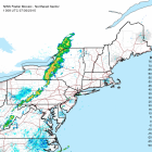
National Weather service radar map for Thursday morning, July 30, 2015 shows one line of storms.

[And with wind gusts come possible tree limbs down and therefore possible disruption of electric service. Are you prepared? We have no idea how severe the threat is, but the Darien Health Department has some suggestions on preparing for power outages.]

Here’s the Darien-specific weather forecast from the weather service for today through Monday. Of course, it’s possible we won’t even get a storm:

Today
Showers and thunderstorms likely, mainly after 5pm. Some of the storms could produce gusty winds and heavy rain. Mostly cloudy, with a high near 84. Southwest wind 8 to 14 mph. Chance of precipitation is 60 percent. New rainfall amounts between a tenth and quarter of an inch, except higher amounts possible in thunderstorms.
Tonight
Showers and thunderstorms likely, mainly before 1am. Some of the storms could produce gusty winds and heavy rain. Cloudy during the early evening, then gradual clearing, with a low around 71. Southwest wind 6 to 10 mph becoming west after midnight. Chance of precipitation is 70 percent. New rainfall amounts between a tenth and quarter of an inch, except higher amounts possible in thunderstorms.
Friday
Sunny, with a high near 88. Northwest wind 6 to 10 mph.
Friday Night
Mostly clear, with a low around 68. West wind 5 to 7 mph becoming calm in the evening.
Saturday
Sunny, with a high near 87. Southwest wind 6 to 10 mph.
Saturday Night
A slight chance of showers and thunderstorms. Partly cloudy, with a low around 69. Chance of precipitation is 20%.
Sunday
Mostly sunny, with a high near 85.
Sunday Night
Partly cloudy, with a low around 70.
Monday
Mostly sunny, with a high near 85.

Leave a Reply

Your email address will not be published. Required fields are marked *