
The National Weather Service has issued a Blizzard Warning for most of the New York Metropolitan region and Connecticut’s Long Island Coast and says Darien could be under 10 to 16 inches of snow through Saturday night, with blustery winds and dangerous travel conditions.
Traveling roads could be “extremely dangerous” and the wind could cause power outages, the weather service says in the Blizzard Warning issued at 4 a.m. and in effect through 7 a.m. Sunday:
EXTREMELY DANGEROUS TRAVEL DUE TO HEAVY SNOWFALL AND
  STRONG WINDS WITH WHITEOUT CONDITIONS LIKELY. SECONDARY AND
  TERTIARY ROADS MAY BECOME IMPASSABLE. STRONG WINDS MAY DOWN
  POWER LINES AND TREE LIMBS.
If an event in town has been scheduled for Saturday, assume it’s cancelled.
Report Any Downed Wires and Power Outages
An update at 8:40 p.m. — Eversource has announced: “Remember: Always stay away from downed lines & report to 9-1-1. Report power outages to 1-800-286-2000 or online.”
UPDATES here:
5:22 p.m.: Here’s the Latest Darien-specific forecast from the National Weather Service as of 3;56 p.m.:
4:05 p.m.: The Connecticut Division of Emergency Management and Homeland Security posted an announcement on Facebook at 3:36 p.m. saying that this Amtrak tweet at 7:10 a.m. is still in force — that is, Amtrak continues to run trains up and down the New Haven Line on a modified schedule: “Amtrak continues modified service on the NEC/East Coast due to winter storm. Latest info here.”
3:51 p.m.: A total of nine customers are without power in Darien, one more in Stamford and 35 in Greenwich, according to Eversource. For the rest of Fairfield County, only two other customers in Danbury are without power.
3:39 p.m.: Metro-North is shutting down train service. Here’s the announcement:
Due to the increased severity of the storm, Metro-North will start to shut down train service this afternoon, Saturday January 23 until further notice so that all trains arrive at their destinations by 6:00 PM. Please refer to the published timetables for Saturday scheduled service or the interactive schedule page. […]
New Haven Line
From New Haven to Grand Central, the 3:25 PM will make all stops to Grand Central.
From Stamford to Grand Central, the 4:02 PM train will make all stops to Grand Central.
From Grand Central to New Haven, the 4:02 PM train will make all stops to New Haven with connections at Stamford, South Norwalk and Bridgeport for service on the Branch Lines.
11:33 p.m.: First Selectman Jayme Stevenson tweeted this picture of flooding at Pear Tree Point Beach:
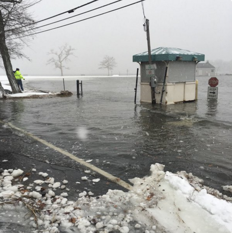
At 11:20 a.m., Stevenson tweeted the picture with this message: “Pear Tree Beach and roadway flooding at high tide.”
11:28 a.m.: Norwalk Transit District is suspending service at noon. The announcement: “ALL Norwalk Transit District services will be SUSPENDED as of 12:00 Noon. The last WHEELS service buses will depart the WHEELS Hub at 11:40am.”
11:23 a.m.: Connecticut Transit says it will start shutting down its bus service at noon and suspend service by 1 p.m.. Here’s the announcement:
CTtransit Stamford area customers: due to winter storm and roadway conditions, service will begin shutting down around noon depending on routes and ridership. By 1:00PM today CTtransit bus service in the Stamford Division will suspend service until further notice when safe operations can resume.
I-BUS customers note: 11:30AM departure from Stamford Transportation Center toward White Plains will be the last trip to operate today.
Bus services along the southwestern CT shoreline including CTtransit Stamford (and I-BUS), Norwalk Transit, Greater Bridgeport Transit, Milford Transit and the Coastal Link will begin shutting down services at noon.
Exact shutdown times will vary by town based on their different schedules, so please check the local bus system websites and e-alerts for more details on the shutdowns, and for when services may resume.
Statewide: customers should anticipate delays and detours due to roadway and traffic conditions as the winter storm spreads and intensifies. Please be cautious if you must travel.
DETOURS
STAMFORD-AREA
Stamford route 13 no service past at Connecticut Ave and Stillwater, turning around and returning to the Station via regular route;
Stamford Rt 11 outbound via Soundview Drive is closed, using inbound routing for outbound travel at this time. No major stops missed – still servicing Greenwich RR station.
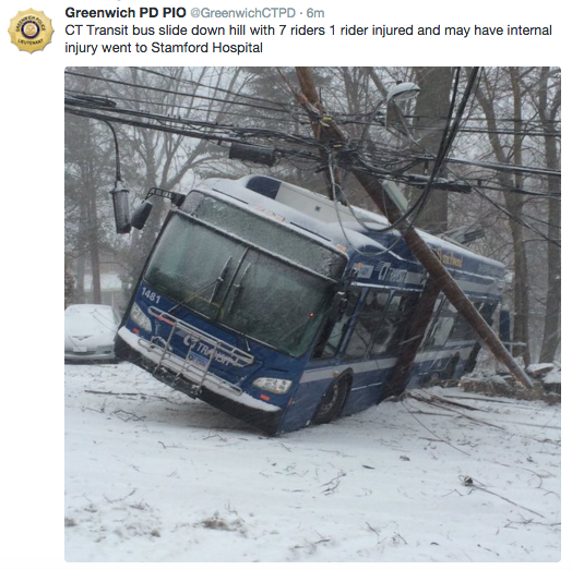
9:25 a.m.: Greenwich Local Firefighters 1042 posted this picture of the same accident on Twitter:

9:15 a.m.: This picture of a bus accident in Greenwich was posted on Twitter by Greenwich police with the tweet “CT Transit bus slide down hill with 7 riders 1 rider injured and may have internal injury went to Stamford Hospital”:
9:13 a.m.: First Selectman Jayme Stevenson is asking residents:
- “Once snow begins, keep off the roads to allow road crews to keep pace with the storm.” (11:23 p.m., Friday tweet)
- “If you use a private snow plow service, remind them not to push snow into roadways. This creates dangerous road conditions.” (7:51 a.m., Saturday tweet)
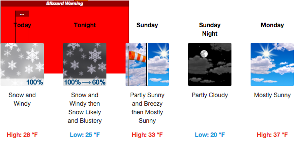
Darien-specific Prediction from National Weather Service
As snow falls throughout the day Saturday and into the night, expect heavy winds, snow drifts and temperatures in the 20s, according to the weather service. The prediction says we can expect better conditions on Sunday and Monday, with temperatures reaching 37 degrees on Monday.
There could be rain after 11 a.m. on Tuesday, according to the forecast for Darien. Here’s the Darien-specific forecast through Wednesday from the National Weather Service as of 6:56 a.m.:
Update, 8:29 a.m.: Coastal Flooding
Tides could be 2 1/2 to 3 1/2 feet above normal at high tide late this morning and 1 1/2 to 2 1/2 feet higher than normal by high tide this evening, according to the weather service, which issued a Coastal Flood Warning for 10 a.m. to 2 p.m. and a Coastal Flood Advisory from 9 p.m. Saturday to 1 a.m. Sunday.
There could be “widespread flooding of vulnerable shore roads and/or shore properties due to the height of the storm tide,” according to the Coastal Flood Warning statement at 4:14 a.m.
Train service
The Metropolitan Transportation Authority says there’s currently “good service” on the New Haven Line but issued a statement at 6:56 a.m., warning:
“Please take care when traveling during inclement weather and allow for additional time to get to your station. Customers should use caution when entering and exiting trains, and on platforms and staircases.
“Delays, cancellations and train combinations may occur depending upon the severity of the snow storm and its impact on our service territory. Customers should listen for station announcements. Be sure to continue to check www.mta.info and the media for updates.”